Well the weather may have been wonderful for our day in Yellowstone, but the following day (Thursday) we made up for it.
Our journey started from Cody, Wyoming (Buffalo Bill Land) and we had planned to make it to Hill City, South Dakota the next day, hopefully to visit a winery and maybe Mount Rushmore, Crazy Horse and Custer. We knew it was a long way but we were rather sleep-deprived and had a few things to do before leaving Cody, including picking up a prescription from Walgreens (this is a good trick to know if you are traveling for a long time. If you use Walgreens, you can have your prescription filled at any one of them in the country. Everything was done online and the drugs were ready for pickup just as if we had been in Sheboygan). I also needed to get a new digital downloader for our cameras. The one I had brought with me managed to break two memory cards and I couldn't risk losing the images. Walgreens obliged once again!
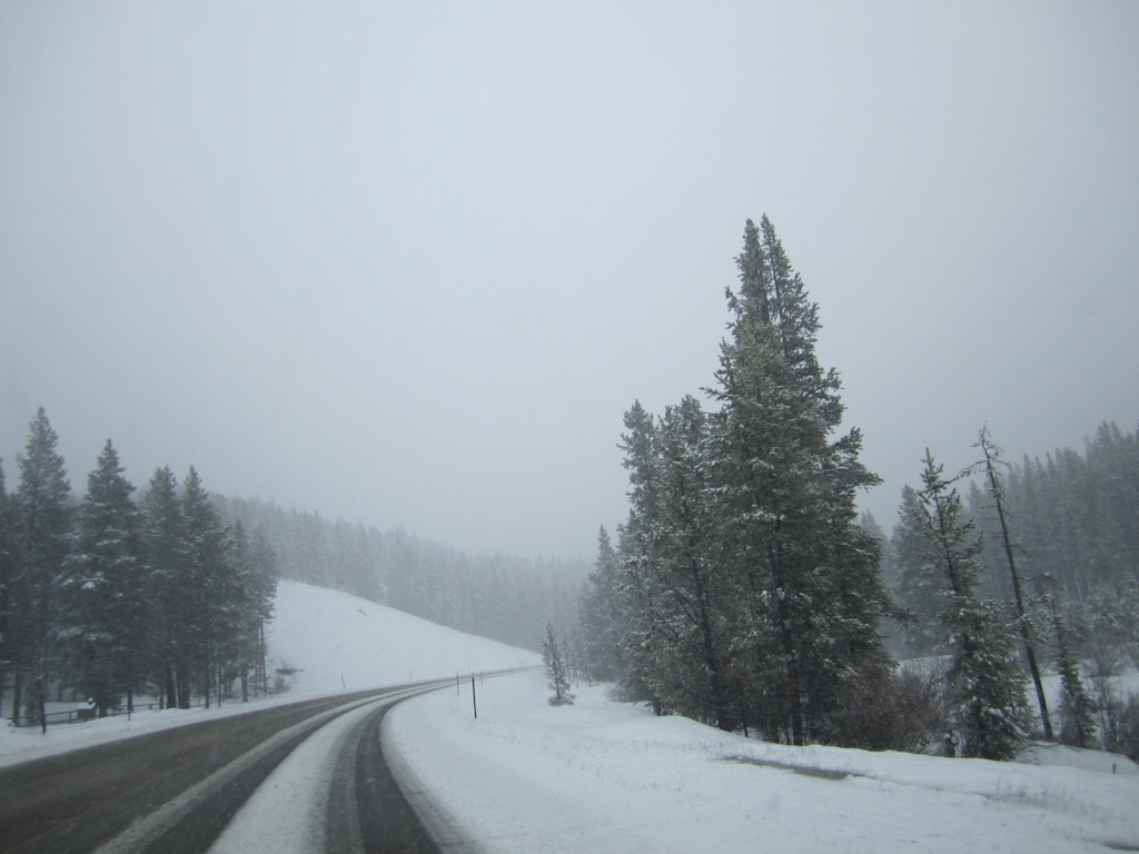
It was cold and drizzling when we left and as we headed off on route 14, the Bighorn Scenic Byway, the rain became heavier. There were some short periods of breaks in the clouds and I marveled at the changes in geology as we progressed along the windy roads.
As this was the first time for either of us in this part of the country, we weren't entirely aware of the topography. I thought that as we headed east, the landscape would turn flatter and we would soon be in the pains. What I had not realized was that we had to navigate a pretty big mountain range first, and as we started to climb, the rain came down more and more heavily. I watched the temperature drop to the low 40s and commented that it may actually be snowing higher up. But the "Road Closed Ahead When Flashing" sign was not flashing which meant the road was open and, I thought, must be OK.
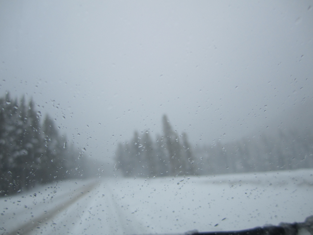
Rain turned to sleet. Sleet turned to snow. My laid back approach to the windy roads turned a little more cautious. One of the biggest problems was the brightness of the snow. I lowered the sun visor to help differentiate the contours of the road, but fog was all around and everything was basically white. There were no other cars on the road, or so it seemed, and there was no cell phone access, but there was also no alternative. We had to get over the mountain and the pass was the only route.
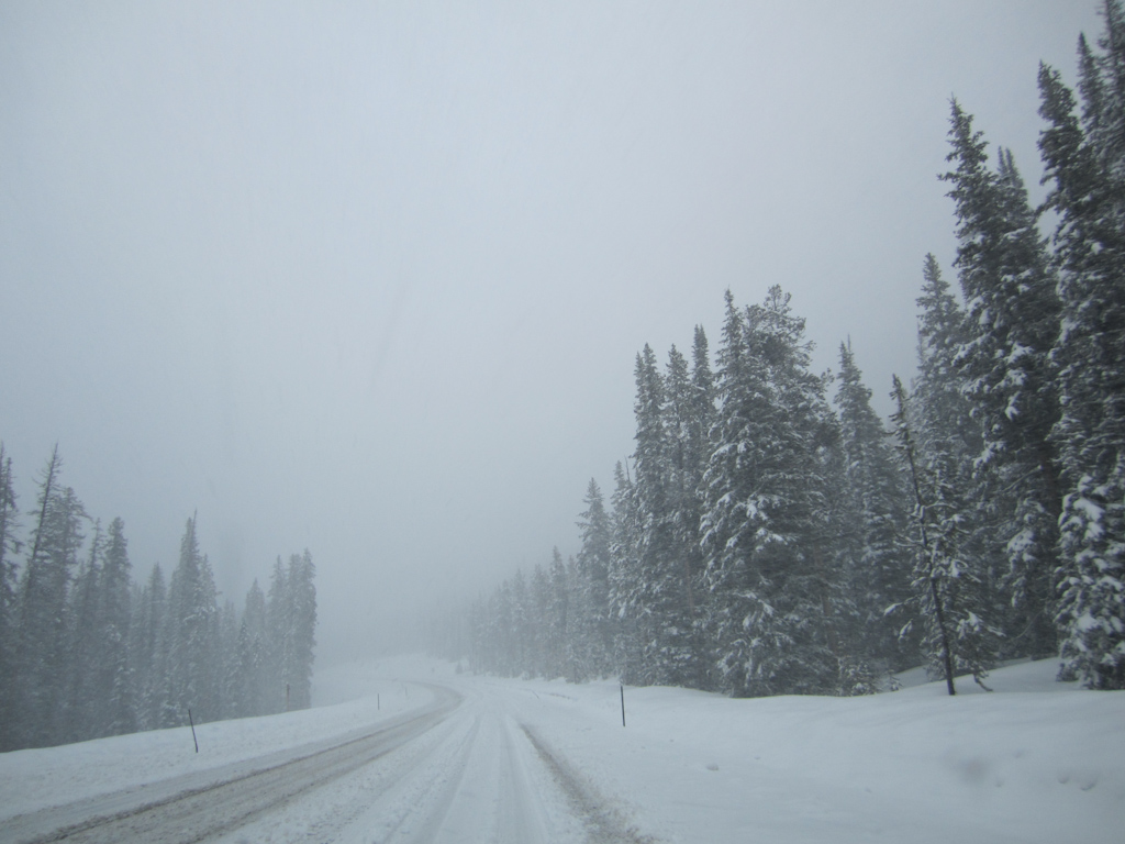
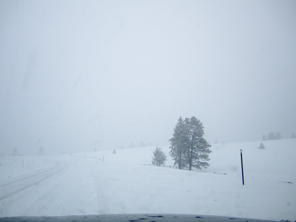
On we went and the snow came down heavily as the temperature dropped to 30 degrees. We reached the summit which was 9,300' - not quite as high as Leadville, CO where we stayed the first week of our trip, but still pretty high. and the snow was blowing sideways. A snowplow appeared coming in the opposite direction and I decided to move to the other side of the road to drive in the cleared tracks. Of course i had to be aware of oncoming traffic which was few and far between, but when it came, it was shrouded in fog and I had to cross the thickest snow in the center of the road to get back on the right side. It felt dangerous and it was, so I opted to drive back on the the fresh snow most of the time, really slowly, and plow through. Although I wished that I still had my Land Rover, the RAV 4 did an admirable job. Only on a couple of occasions did the ABS brakes shudder as I lost a little traction, but we made it to the top. The drop down was eleven miles of 8% gradient. I put the car in 2nd (low) gear and kept my foot away from the brake as much as possible. Those eleven miles took almost an hour and seemed interminable. Finally the snow turned back to sleet and then to rain and I breathed a sigh of relief as Ginnie massaged my shoulders, which were tense from the almost three hours of intense concentration. My right thigh also ached and mentally I was exhausted. Although I never feared for our lives, I was certainly concerned as this was probably the worst conditions I have ever driven in, and certainly the longest sustained white-out conditions I have experienced. Although we couldn't see it, I knew there were sheer drops off the side of the road. I was pleased that there were barriers almost the whole way down and thankful for the Wyoming taxpayers who presumably footed the bill to install them! Through this whole episode, Hopi was uncharacteristically nervous and anxious, panting and trembling even before the white-out started. I think he could sense the danger ahead, or sense our concern. Doggies are remarkably perceptive!
As a result of this slow start to the day, we didn't make it as far as Hill City, SD and stopped at a pretty crummy Holiday Inn (why are they less good than the cheaper Holiday Inn Express?) for the night. Ironically, there was a Culver's next door. I was grateful to my friend Craig Culver for having the foresight to build a restaurant right there, and we filled our stomachs with butter burgers and fell into bed, too exhausted to blog.
Not may photos today but the following give an idea of the mountain pass conditions. This was certainly a day on the trip that we will remember and eventually we will look back on it fondly, as we do on every day. The main thing is that we are safe!
Our journey started from Cody, Wyoming (Buffalo Bill Land) and we had planned to make it to Hill City, South Dakota the next day, hopefully to visit a winery and maybe Mount Rushmore, Crazy Horse and Custer. We knew it was a long way but we were rather sleep-deprived and had a few things to do before leaving Cody, including picking up a prescription from Walgreens (this is a good trick to know if you are traveling for a long time. If you use Walgreens, you can have your prescription filled at any one of them in the country. Everything was done online and the drugs were ready for pickup just as if we had been in Sheboygan). I also needed to get a new digital downloader for our cameras. The one I had brought with me managed to break two memory cards and I couldn't risk losing the images. Walgreens obliged once again!
It was cold and drizzling when we left and as we headed off on route 14, the Bighorn Scenic Byway, the rain became heavier. There were some short periods of breaks in the clouds and I marveled at the changes in geology as we progressed along the windy roads.
As this was the first time for either of us in this part of the country, we weren't entirely aware of the topography. I thought that as we headed east, the landscape would turn flatter and we would soon be in the pains. What I had not realized was that we had to navigate a pretty big mountain range first, and as we started to climb, the rain came down more and more heavily. I watched the temperature drop to the low 40s and commented that it may actually be snowing higher up. But the "Road Closed Ahead When Flashing" sign was not flashing which meant the road was open and, I thought, must be OK.
Rain turned to sleet. Sleet turned to snow. My laid back approach to the windy roads turned a little more cautious. One of the biggest problems was the brightness of the snow. I lowered the sun visor to help differentiate the contours of the road, but fog was all around and everything was basically white. There were no other cars on the road, or so it seemed, and there was no cell phone access, but there was also no alternative. We had to get over the mountain and the pass was the only route.
On we went and the snow came down heavily as the temperature dropped to 30 degrees. We reached the summit which was 9,300' - not quite as high as Leadville, CO where we stayed the first week of our trip, but still pretty high. and the snow was blowing sideways. A snowplow appeared coming in the opposite direction and I decided to move to the other side of the road to drive in the cleared tracks. Of course i had to be aware of oncoming traffic which was few and far between, but when it came, it was shrouded in fog and I had to cross the thickest snow in the center of the road to get back on the right side. It felt dangerous and it was, so I opted to drive back on the the fresh snow most of the time, really slowly, and plow through. Although I wished that I still had my Land Rover, the RAV 4 did an admirable job. Only on a couple of occasions did the ABS brakes shudder as I lost a little traction, but we made it to the top. The drop down was eleven miles of 8% gradient. I put the car in 2nd (low) gear and kept my foot away from the brake as much as possible. Those eleven miles took almost an hour and seemed interminable. Finally the snow turned back to sleet and then to rain and I breathed a sigh of relief as Ginnie massaged my shoulders, which were tense from the almost three hours of intense concentration. My right thigh also ached and mentally I was exhausted. Although I never feared for our lives, I was certainly concerned as this was probably the worst conditions I have ever driven in, and certainly the longest sustained white-out conditions I have experienced. Although we couldn't see it, I knew there were sheer drops off the side of the road. I was pleased that there were barriers almost the whole way down and thankful for the Wyoming taxpayers who presumably footed the bill to install them! Through this whole episode, Hopi was uncharacteristically nervous and anxious, panting and trembling even before the white-out started. I think he could sense the danger ahead, or sense our concern. Doggies are remarkably perceptive!
As a result of this slow start to the day, we didn't make it as far as Hill City, SD and stopped at a pretty crummy Holiday Inn (why are they less good than the cheaper Holiday Inn Express?) for the night. Ironically, there was a Culver's next door. I was grateful to my friend Craig Culver for having the foresight to build a restaurant right there, and we filled our stomachs with butter burgers and fell into bed, too exhausted to blog.
Not may photos today but the following give an idea of the mountain pass conditions. This was certainly a day on the trip that we will remember and eventually we will look back on it fondly, as we do on every day. The main thing is that we are safe!


 RSS Feed

